The mountains are freedom, discovery, adventure. But to fully enjoy them, you need the right tools. Mountain Maps is the perfect trekking app to plan truly customized itineraries, thanks to artificial intelligence, and navigate the mountains even without a connection.
Most features are free, while some advanced options are available with a Premium subscription for an even more complete experience.
Let’s take a look at what you can do with the app and why it’s different from the others.
All features of Mountain Maps
Mountain Maps is much more than just a map: it’s your ideal travel buddy in the mountains. This app, in addition to providing detailed and personalized trekking routes, helps you plan every hike, even offline. Whether you want to explore new trails, avoid getting lost along the way, or share your adventures with friends, the app offers tools designed for every type of hiker.
Consult Detailed Mountain Maps
View precise mountain maps, including 3D or satellite mode, and study the terrain before your hike. Quickly discover slopes, trails, and points of interest at a glance.
Additionally, you can check contour lines to better understand altitude variations and view CAI trails to safely plan your route.
If you’re a skiing enthusiast, you’ll also find a dedicated ski slopes layer, with detailed information on tracks and lifts.
Plan your hike in just a few steps with Mountain Maps trekking app
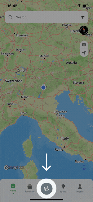
We know how important it is to have precise information before setting off on a hike. With Mountain Maps, you can plan your route quickly and easily by clicking on “Plan” in the bottom menu.
- Choose your activity filters: First, select between walking and skiing, making the app a navigator for ski slopes as well. You can also decide to include via ferrata or stroller access and set trail conditions.
- Enter itinerary details: Choose your departure, arrival, and add any intermediate points to personalize the route.
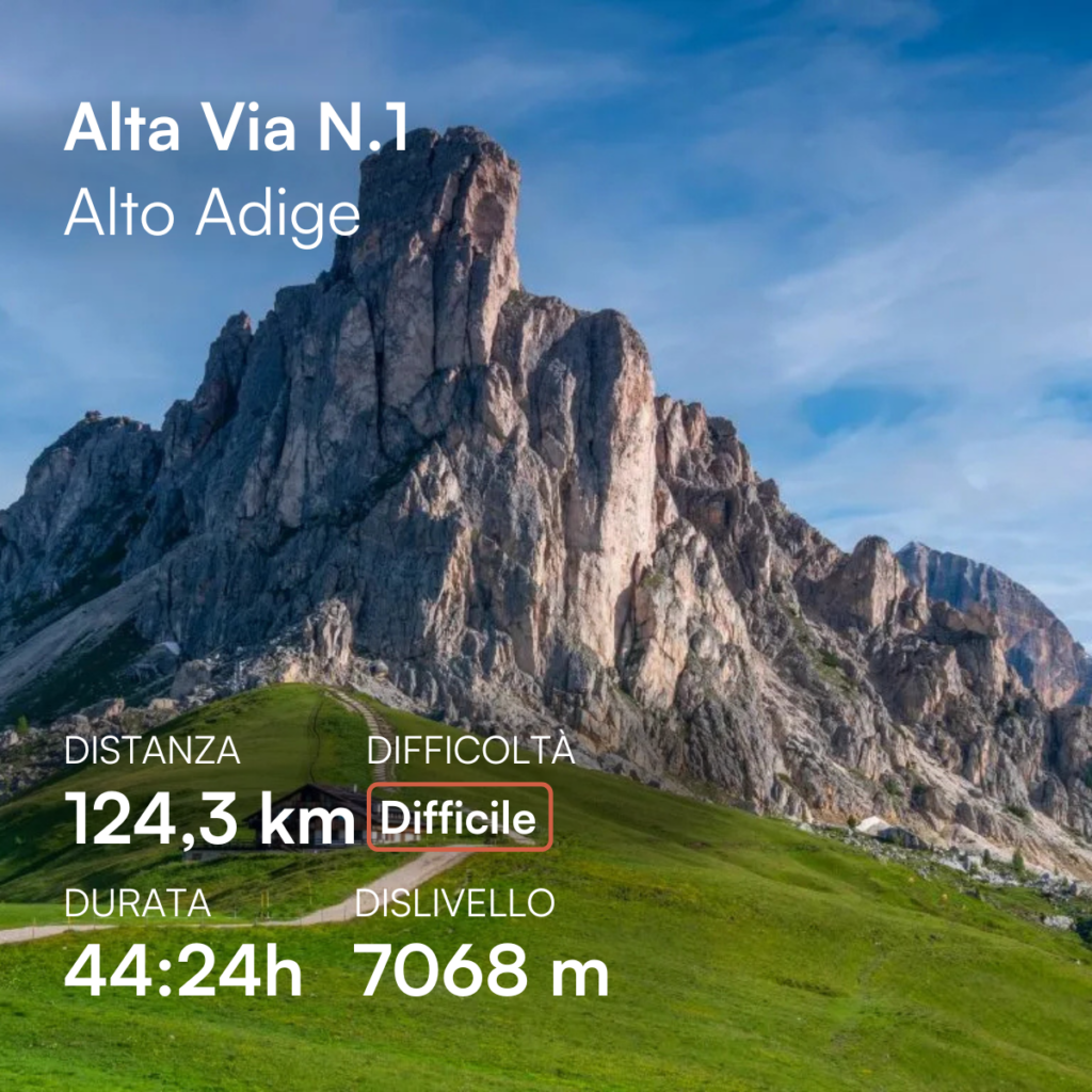
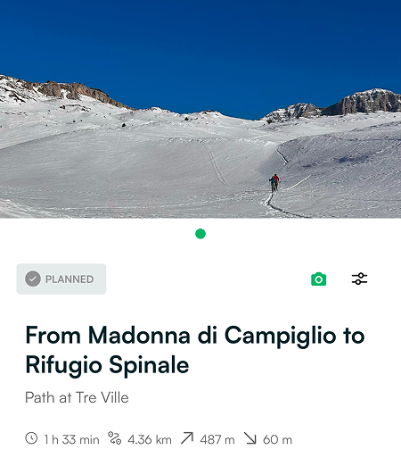
- Check the route details: Once the itinerary is generated, click on “Let’s go!” to view duration, distance, elevation gain, and other useful information.
- Start navigation: When you’re ready, press “Navigate” to follow the route with precise directions.
Your trek is calculated, but it doesn’t end here.
- Share it with your adventure buddies: You can easily export the track and share it with your friends, so they can view it directly on the app.
- Upload your photos: During or after the hike, you can upload images of scenic spots and share them with other hikers.
- Export the track: If you want to save or share your itinerary on another device, export it in .gpx format.
No uncertainty, no wasted time: just one click and you’re ready to go.
Always find new ideas with the Mountain Maps trekking app
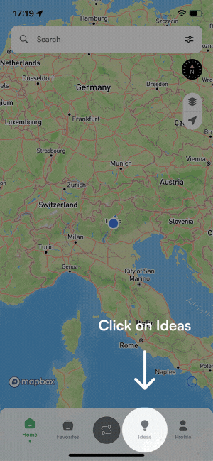
If you already knew that trekking planning would be useful, the “Ideas” feature is that something you didn’t know you needed.
Mountain Maps is the only outdoor app that uses artificial intelligence to suggest new itineraries, customized just for you.
You have two options:
From “Suggestions,” all you need to do is answer 3 simple questions, and the app will select the most suitable treks for you, allowing you to discover hidden gems you might never have considered.
- What area do you want to start from? Enter the starting point of your trek.
- What difficulty do you desire for the route? Choose from easy, medium, or hard.
- How long do you want to walk? Set the approximate duration of your hike.
Click on “Recommend” and the app will show you several trekking options near the selected starting point, respecting all the preferences you indicated.
The second way to find new trekking ideas is by going to “Similar trails”. Here, things get even simpler.
- Select a path from your “Favorites” or “History”.
- Click on “Create Similar”.
- Choose the geographic area where you want the app to suggest a trek.
- Scroll through the itinerary suggestions. When you find the perfect one, click “Confirm” to start your adventure.

Other features
Use offline maps, even without an internet connection
The highest peaks offer breathtaking views, but often, the internet lets you down at the most beautiful moment. That’s why Mountain Maps allows you to download maps offline for free before your trip.
Currently, offline maps are available for all of Italy and Austria.
When you’re in the mountains and the signal disappears, the map will activate automatically, allowing you to continue following your route without worries. No more fear of getting lost, just the joy of your adventure.
Upload and view photos of routes
Want to know what to expect along the way? Mountain Maps lets you view photos uploaded by other explorers, so you can get an idea of the scenic viewpoints and points of interest along the trail.
And it doesn’t stop there: you can also upload your own photos to help other hikers discover the details of the path, share breathtaking views, and enrich the Mountain Maps community experience.
Import and export your .gpx tracks
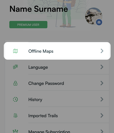
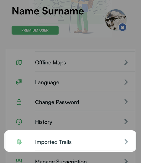
Do you already have a .gpx track of your route? Import it into Mountain Maps to have everything you need at your fingertips directly in the app. Simply click on the profile icon at the top right, scroll down to the “Imported Trails” section, and select “Load Trail”. In just a few seconds, your itinerary will be ready to be viewed and navigated.
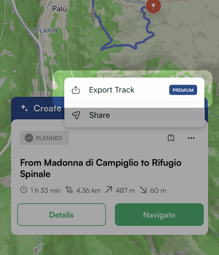
Do you want to share your itinerary with a friend? Once you’ve created the route, click on the three dots in the route information box and choose from:
- Share, so your friends can view it directly in the app.
- Export the track in .gpx format (feature available only for Premium users).
Why choose Mountain Maps as your trekking app for adventures
- Personalized trekking with AI: The app uses artificial intelligence to recommend trekking routes tailored to your needs. It selects the most suitable paths based on your preferences.
- Detailed offline maps: You’ll have access to detailed mountain maps that you can consult for free even offline, so you’re not dependent on internet connection during your hikes.
- Simple and clear interface: On the home screen, you won’t find the overwhelming clutter seen in many apps that suggest countless similar routes from the community. Mountain Maps offers a streamlined, focused experience.
Whether you’re an experienced hiker or a nature walk enthusiast, Mountain Maps is the tool that makes every mountain adventure simpler, safer, and more enjoyable.
Q&A – Frequently Asked Questions
1. Is Mountain Maps free?
Yes, you can use Mountain Maps for free to do many things, such as: viewing detailed mountain maps, even in 3D; planning hikes and sharing them with your friends; downloading offline maps for all of Italy and Austria; getting a suggested itinerary by answering just three questions.
There is also a Premium version that gives you access to additional features. You can learn more by clicking here.
2. Can I download maps offline?
Yes, you can download maps of all of Italy and Austria for free and use them offline. The maps will activate automatically when your phone is not connected to the Internet.
If your connection is weak but not completely absent, we recommend enabling airplane mode to make the offline maps appear.
3. What is Premium and what are its benefits?
The Premium version of Mountain Maps offers a range of exclusive benefits for an even more complete experience. With the Premium plan, you get access to:
- Similar route suggestions: AI will recommend similar itineraries in your preferred area.
- Custom route export: Export your tracks in .gpx format to relive and share your adventures.
- Ski navigation: Plan ski routes with personalized information based on slope difficulty.
- Priority access to new features: Try app updates in advance and contribute to its improvement.
For more information, visit the dedicated page by clicking here.
4. Does Mountain Maps work without an internet connection?
Yes, Mountain Maps works without an internet connection if you have previously downloaded the offline maps of the area you’re interested in.
5. Does Mountain Maps offer maps for all mountain areas?
Yes, Mountain Maps offers detailed maps for all of Italy and Austria. You can view mountain maps, including 3D and satellite modes, and use them offline to explore the highest peaks without any connection issues.
6. How can I find new itineraries with Mountain Maps?
You can discover new itineraries using the “Ideas” feature. The artificial intelligence will suggest personalized routes based on your preferences. Just answer 3 simple questions about the starting point, difficulty, and desired duration.
Alternatively, you can select a route from your Favorites or History and ask the app to suggest similar hikes in the area.
7. Is Mountain Maps suitable for skiers?
Yes, Mountain Maps is also perfect for skiers. The app includes a ski navigator, allowing you to plan customized routes based on the difficulty level of the slopes.